Seattle

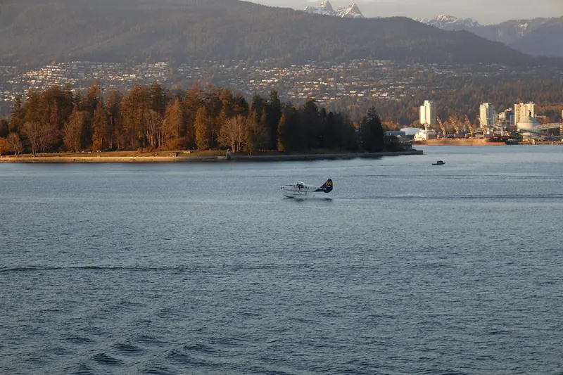
Vancouver
United States · Multi-city itinerary
Pacific Northwest itinerary — March 2027
By Tripsapien Research · Updated May 20, 2026
March 2027 is a shoulder-season time for the Pacific Northwest trip (Seattle & Vancouver). Daytime highs run from about 10°C / 50°F to 12°C / 54°F across the stops. Plan around 6–8 days for the full Seattle & Vancouver loop. Tripsapien checks every place on your list against your exact dates — hours, closures and booking pressure at each stop.
The route
About 6–8 days · 2 cities
The Pacific Northwest across the border: Seattle, with Pike Place Market and the Space Needle, and Vancouver, ringed by mountains and ocean with Stanley Park at its heart. The two are roughly three hours apart by car or the Cascades train.
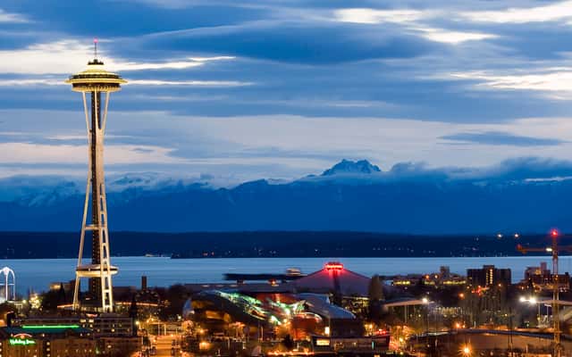
Seattle
Seattle in March
Temperature
54°F / 40°F
12.3°C / 4.4°C
Precipitation
17d
4.1in · 105mm
Daylight
11.6h
March is cool and showery, good for cherry blossoms, markets, and covered food routes.
March is cool and showery, good for cherry blossoms, markets, and covered food routes.
City overview
Seattle is the Puget Sound city where Elliott Bay, Lake Washington, the Ship Canal, and the Olympic and Cascade mountain views frame a compact but steep urban core. Pike Place Market, Capitol Hill, Fremont, Ballard, Belltown, the International District, and Seattle Center give the city its mix of seafood, coffee, music, tech, ferries, and long gray-season weather.
Food & drink
Seattle food is seafood, coffee, and immigrant counter culture: salmon is grilled or smoked, Dungeness crab and oysters come from cold Pacific waters, chowder lands in market bowls, and teriyaki shops turn grilled chicken with sweet soy sauce into a city staple. Pike Place Market, Ballard seafood rooms, the International District, Capitol Hill restaurants, and the Fremont-Ballard brewery belt add pho, sourdough, seasonal berries, roasters, and taprooms.
Top sights
Ranked for March suitability using weather, setting, ratings, and review volume.
- 1Museum of Flight
- 2Chihuly Garden and Glass
- 3Museum of Pop Culture
- 4Seattle Art Museum
- 5Pioneer Square and Smith Tower
- 6Ballard Locks
- 7Olympic Sculpture Park
- 8Pike Place Market
- 9Space Needle
- 10Fremont public art and Gas Works Park
 1
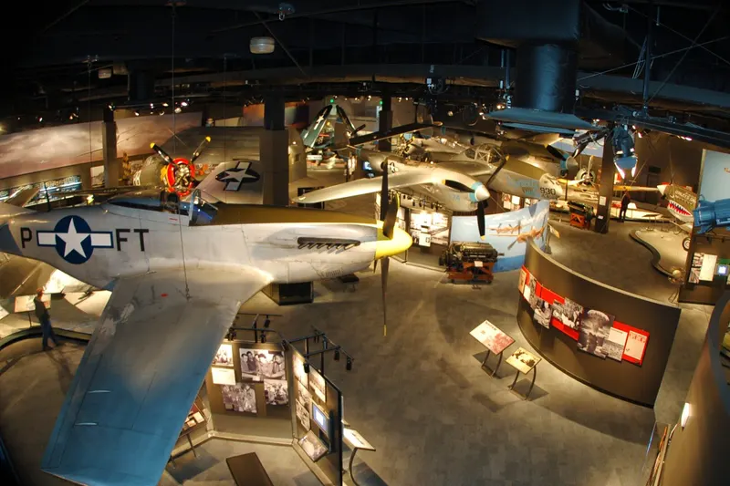
1Museum of Flight
4.8★ · 18,058indoorOpen dailyThe museum began in the 1960s and now fills Boeing Field galleries with aircraft, spacecraft, the original Boeing Red Barn, Concorde, Air Force One, and aviation archives. It is south of downtown on East Marginal Way.
Wikipedia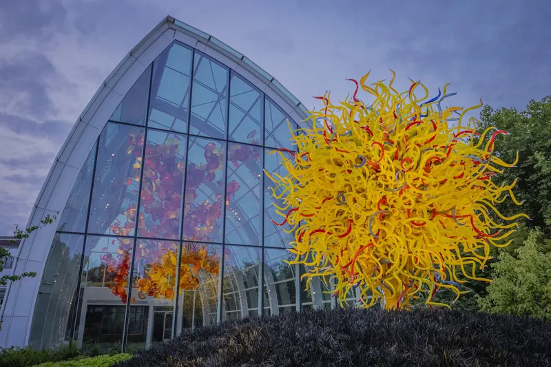 2
2Chihuly Garden and Glass
4.7★ · 24,143indoorOpen dailyThe glass-art museum opened at Seattle Center in 2012 with Dale Chihuly installations, a glasshouse, gardens, and large-scale color works. It is directly beside the Space Needle and near the Monorail station.
Wikipedia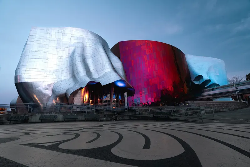 3
3Museum of Pop Culture
4.6★ · 19,081indoorOpen dailyFrank Gehry designed the museum building, opened in 2000 as the Experience Music Project. Exhibits cover music, science fiction, games, film, and Seattle's rock history beside Seattle Center.
Wikipedia
Show 7 more sights
- 4Seattle Art Museum
- 5Pioneer Square and Smith Tower
- 6Ballard Locks
- 7Olympic Sculpture Park
- 8Pike Place Market
- 9Space Needle
- 10Fremont public art and Gas Works Park
Neighborhoods
 1
1Downtown, Pike Place, and Waterfront
The core is steep and busy, with Pike Place Market, Seattle Art Museum, ferries, office towers, waterfront piers, Westlake transit, and Elliott Bay views.
 2
2Capitol Hill
Capitol Hill is dense and nightlife-heavy, with music venues, bars, cafes, Volunteer Park, rainbow crosswalks, light rail, and restaurant corridors around Pike and Pine.
 3
3Belltown and Seattle Center
This side is vertical and event-ready, with the Space Needle, MoPOP, Chihuly, Olympic Sculpture Park, bars, hotels, and quick access to the waterfront.
 4
4Fremont and Wallingford
North of Lake Union, Fremont and Wallingford feel independent and playful, with public art, breweries, canal paths, Gas Works Park, vintage shops, and brunch spots.
 5
5Ballard
Ballard is maritime and food-focused, with the locks, Nordic Museum, breweries, old Ballard Avenue, seafood restaurants, and Golden Gardens nearby.
 6
6International District and Pioneer Square
This south-downtown area is historic and food-rich, with brick blocks, Smith Tower, Uwajimaya, dim sum, noodle shops, stadium crowds, and transit links.
Getting around
Sound Transit Link light rail, King County Metro buses, streetcars, the Seattle Center Monorail, ferries, and ORCA cards handle most visitor routes. Downtown is walkable but steep, while Ballard, Fremont, West Seattle, and Mount Rainier require more transfer or car planning.
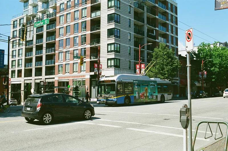
Vancouver
Vancouver in March
Temperature
50°F / 38°F
10.1°C / 3.3°C
Precipitation
14d
4.2in · 106mm
Daylight
11.6h
Sea
46°F
7.8°C
March brings early blossoms and frequent showers, so layer for seawall walks.
March brings early blossoms and frequent showers, so layer for seawall walks.
City overview
Vancouver is a Pacific harbor city squeezed between Burrard Inlet, English Bay, the Fraser River, and the North Shore mountains, with glass towers, beaches, rainforest, and ferries all close together. Downtown, Gastown, Yaletown, Kitsilano, Granville Island, and the West End each give a different version of the same city: water views, mountain weather, and food shaped by the Pacific Rim.
Food & drink
Vancouver food is Pacific Rim and coastal: sushi, salmon, spot prawns, dim sum, ramen, Japadog hot dogs, butter chicken, poutine, and Nanaimo bars all fit the city. Granville Island Public Market, Richmond night-market trips, Robson Street ramen, Commercial Drive cafes, and Chinatown bakeries are the first route.
Top sights
Ranked for March suitability using weather, setting, ratings, and review volume.
- 1Museum of Anthropology at UBC
- 2Canada Place
- 3Vancouver Art Gallery
- 4Grouse Mountain
- 5Dr. Sun Yat-Sen Classical Chinese Garden
- 6Stanley Park and Seawall
- 7Queen Elizabeth Park
- 8Granville Island Public Market
- 9Capilano Suspension Bridge Park
- 10Gastown and Steam Clock
 1
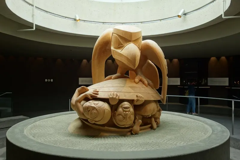
1Museum of Anthropology at UBC
4.7★ · 5,740indoorOpen dailyArthur Erickson designed the museum building, opened in 1976 on the University of British Columbia campus above the Strait of Georgia. The Great Hall, Northwest Coast works, and outdoor poles make it one of the city's most important cultural stops.
Wikipedia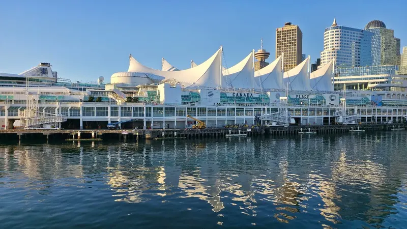 2
2Canada Place
4.6★ · 26,935indoorClosed Sat/SunCanada Place opened for Expo 86 with a sail-like roof, cruise terminal, convention space, promenade, and harbor views. It sits beside Waterfront Station, Coal Harbour, and the SeaBus terminal.
Wikipedia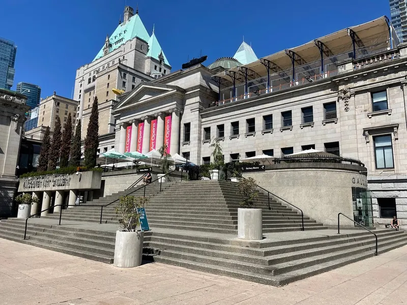 3
3Vancouver Art Gallery
4.3★ · 9,113indoorOpen dailyThe gallery occupies the 1906 former provincial courthouse designed by Francis Rattenbury and has been in the building since 1983. Its collection is strong on Emily Carr, British Columbia art, photography, and contemporary exhibitions downtown.
Wikipedia
Show 7 more sights
- 4Grouse Mountain
- 5Dr. Sun Yat-Sen Classical Chinese Garden
- 6Stanley Park and Seawall
- 7Queen Elizabeth Park
- 8Granville Island Public Market
- 9Capilano Suspension Bridge Park
- 10Gastown and Steam Clock
Neighborhoods
 1
1Downtown, Coal Harbour, and Waterfront
The core is compact and glassy, with Canada Place, Waterfront Station, cruise ships, office towers, harbor paths, seaplanes, and North Shore views.
 2
2Gastown and Chinatown
This side is historic and brick-lined, with Water Street, the steam clock, Chinatown gates, Dr. Sun Yat-Sen garden, cocktail bars, and social-service complexity.
 3
3Yaletown and False Creek
Yaletown is polished and waterfront-adjacent, with converted warehouses, marina paths, restaurants, David Lam Park, and little ferries to Granville Island.
 4
4West End and English Bay
The West End is leafy and residential, with Stanley Park access, Davie Village, Robson Street, English Bay beach, and sunset crowds.
 5
5Kitsilano and Point Grey
Kits is beachy and relaxed, with Kitsilano Beach, West 4th shops, yoga studios, cafes, and routes toward UBC and Jericho Beach.
 6
6Commercial Drive and Mount Pleasant
The east-side belt is independent and food-heavy, with cafes, breweries, music rooms, vintage shops, Italian roots, and Main Street design stores.
Getting around
TransLink runs SkyTrain, buses, SeaBus, and West Coast Express with Compass Card or contactless payment. Downtown, the Seawall, and False Creek work well on foot, bike, or small ferry, while UBC, North Shore, Richmond, and Whistler need more time buffers.
Best time to do the Pacific Northwest trip
In March, the Pacific Northwest trip runs daytime highs from 10°C / 50°F to 12°C / 54°F, with nights down to about 3°C / 37°F at the coolest stop. It is one of the wetter months, with up to 17 rainy days at the wettest stop. Weighed across both stops, March is a shoulder-season time to travel.
The most comfortable months across Seattle & Vancouver are July, August and September, based on average daytime temperatures and rainfall at every stop. March 2027 is a quieter shoulder season to go.
Check this route against your dates
Tripsapien starts with the sights on this page or places you paste, then checks hours, closures, booking pressure and neighborhoods for your exact March dates — across every city on the Pacific Northwest trip.
Plan this Pacific Northwest tripCommon questions about the Pacific Northwest trip
- When is the best time to do the Pacific Northwest trip?
- The most comfortable months across Seattle, Vancouver are July, August and September, based on average daytime temperatures and rainfall at each stop. March is a shoulder-season time — see the per-stop weather below for the exact picture in March 2027.
- How many days do you need for the Pacific Northwest trip?
- A comfortable Pacific Northwest trip runs about 6–8 days, allowing roughly Seattle 3, Vancouver 3 nights plus travel between stops. Add a day if you want a slower pace or extra day trips.
- What's the route for the Pacific Northwest trip?
- The classic order is Seattle & Vancouver. Each city below has its own March weather, events and top-sights list.
- Will the sights be open during my March Pacific Northwest trip?
- Opening days and hours vary by weekday, season and public holiday, and they differ from city to city on a multi-stop trip. Paste your Pacific Northwest list into Tripsapien and it checks every place in Seattle, Vancouver against your exact dates, flagging closures and what needs booking ahead before you go.