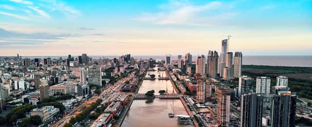
Buenos Aires
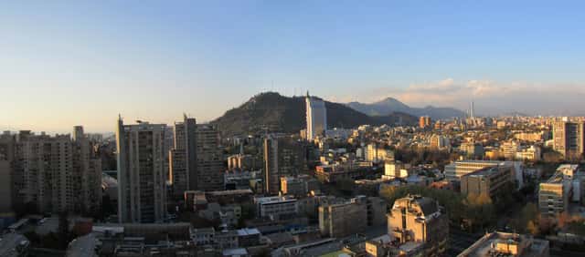
Santiago
South America · Multi-city itinerary
Southern Cone itinerary — May 2027
By Tripsapien Research · Updated May 20, 2026
May 2027 is a good time for the Southern Cone trip (Buenos Aires & Santiago). Daytime highs run from about 19°C / 66°F to 20°C / 68°F across the stops. Plan around 7–9 days for the full Buenos Aires & Santiago loop. Tripsapien checks every place on your list against your exact dates — hours, closures and booking pressure at each stop.
The route
About 7–9 days · 2 cities
Two southern capitals across the Andes: tango-and-steak Buenos Aires on the River Plate, and Santiago beneath the snow-capped Andes, the gateway to Chilean wine country and the coast at Valparaíso. A two-hour flight links them.
Buenos Aires
Buenos Aires in May
Temperature
67°F / 52°F
19.4°C / 11.1°C
Precipitation
5d
3.7in · 94mm
Daylight
10.2h
Sea
65.1°F
18.4°C
May brings comfortable autumn weather for Recoleta, Palermo parks, and long cafe stops.
May brings comfortable autumn weather for Recoleta, Palermo parks, and long cafe stops.
City overview
Buenos Aires is a Rio de la Plata port city whose identity comes from immigrant theatres, political plazas, tango halls, and apartment-lined barrios rather than one monumental old core. Recoleta and Palermo carry the leafy cafe-and-gallery stay, San Telmo and La Boca keep the tango and port history visible, and Puerto Madero adds the glass-and-dockland skyline beside the Costanera Sur reserve.
Food & drink
Buenos Aires eating revolves around asado, bife de chorizo, choripán, empanadas, milanesa, fugazzeta pizza, dulce de leche, and late-night helado. Mercado de San Telmo, Don Julio in Palermo, Güerrin on Avenida Corrientes, and neighborhood parrillas around Recoleta and Palermo show the range without leaving the city.
Top sights
Ranked for May suitability using weather, setting, ratings, and review volume.
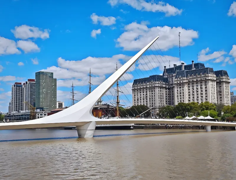
- 1Puente de la Mujer
- 2Plaza de Mayo and Casa Rosada
- 3Palacio Barolo
- 4Recoleta Cemetery
- 5Teatro Colón
- 6El Ateneo Grand Splendid
- 7Museo Nacional de Bellas Artes
- 8MALBA
- 9Caminito
- 10La Bombonera
 1
1Puente de la Mujer
4.7★ · 87,730outdoorOpen dailySantiago Calatrava designed the rotating white footbridge that opened in Puerto Madero in 2001. It crosses Dock 3 near restaurants, the frigate ARA Presidente Sarmiento, and the Costanera Sur ecological reserve.
Wikipedia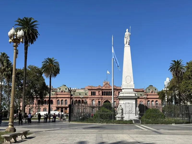 2
2Plaza de Mayo and Casa Rosada
4.6★ · 140,907outdoorPlaza de Mayo has been the political heart since the colonial Cabildo and the 1810 revolution. The Casa Rosada presidential palace faces the square from Balcarce Street, with its pink facade and balconies above the old riverbank.
 3
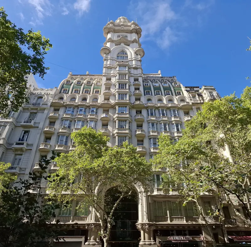
3Palacio Barolo
4.6★ · 28,924outdoorOpen dailyMario Palanti completed this Dante-inspired office tower in 1923 for textile magnate Luis Barolo, with floors and lighthouse symbolism tied to the Divine Comedy. Guided tours climb from Avenida de Mayo toward views of Congreso and the Obelisco.
Wikipedia
Show 7 more sights
- 4Recoleta Cemetery
- 5Teatro Colón
- 6El Ateneo Grand Splendid
- 7Museo Nacional de Bellas Artes
- 8MALBA
- 9Caminito
- 10La Bombonera
Neighborhoods
 1
1Recoleta
Recoleta feels Parisian and polished, with Avenida Alvear mansions, Recoleta Cemetery, Plaza Francia, El Ateneo, and museum lawns close together.
 2
2Palermo Soho and Palermo Hollywood
Palermo is the long cafe-and-nightlife district, with Plaza Serrano, Armenia, Gorriti, Humboldt, design shops, parrillas, and late bars under plane trees.
 3
3San Telmo
San Telmo is cobblestone Buenos Aires, anchored by Defensa Street, Plaza Dorrego, Mercado de San Telmo, antique stalls, and Sunday tango crowds.
 4
4La Boca
La Boca is vivid but bounded, with Caminito, La Bombonera, Quinquela Martín murals, and tourist restaurants safest in daylight and on the main lanes.
 5
5Puerto Madero
Puerto Madero is the clean dockland reset, with brick warehouses, Puente de la Mujer, upscale steakhouses, hotels, and Costanera Sur reserve paths.
 6
6Belgrano
Belgrano feels residential and affluent, with Barrancas de Belgrano, Chinatown on Arribeños, Avenida Cabildo shops, and old houses near the Mitre train.
Getting around
Use a SUBE card for Subte lines, colectivos, commuter trains, and airport buses; Line D is useful for Palermo and Recoleta, while Line A follows Avenida de Mayo. Taxis and rideshares are practical after late dinners, and La Boca is better reached by bus or taxi than by a long walk from San Telmo.
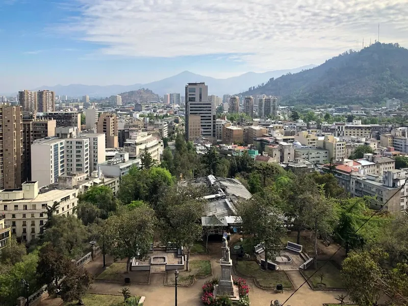
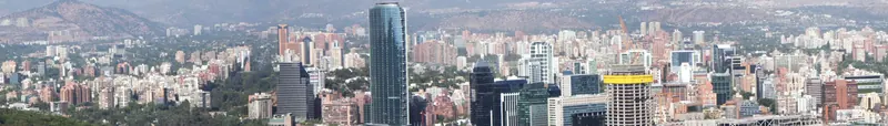
Santiago
Santiago in May
Temperature
68°F / 41°F
20.2°C / 5.1°C
Precipitation
4d
1.8in · 45mm
Daylight
10.3h
May starts the wetter season and cooler nights, so keep museums and La Moneda cultural center ready.
May starts the wetter season and cooler nights, so keep museums and La Moneda cultural center ready.
City overview
Santiago fills Chile central valley between the Andes and the coastal range, with the Mapocho River, hill parks, vineyards, and a long east-west metro spine shaping most visits. The useful first map is Santiago Centro for civic monuments, Lastarria and Bellavista for culture and nightlife, Providencia for transit and food, and Las Condes or Vitacura for the modern business edge.
Food & drink
Santiago food moves between completo hot dogs, pastel de choclo, cazuela, empanadas de pino, humitas, churrasco sandwiches, seafood, and Chilean wine. Mercado Central, La Vega, Fuente Alemana, Barrio Italia, Bellavista, and Providencia wine bars give the clearest first route.
Top sights
Ranked for May suitability using weather, setting, ratings, and review volume.
- 1Cerro San Cristobal
- 2Costanera Center and Sky Costanera
- 3Cerro Santa Lucia
- 4La Moneda Palace
- 5Mercado Central and La Vega
- 6Plaza de Armas
- 7Metropolitan Cathedral of Santiago
- 8Museo Chileno de Arte Precolombino
- 9La Chascona
- 10Barrio Lastarria and GAM
 1
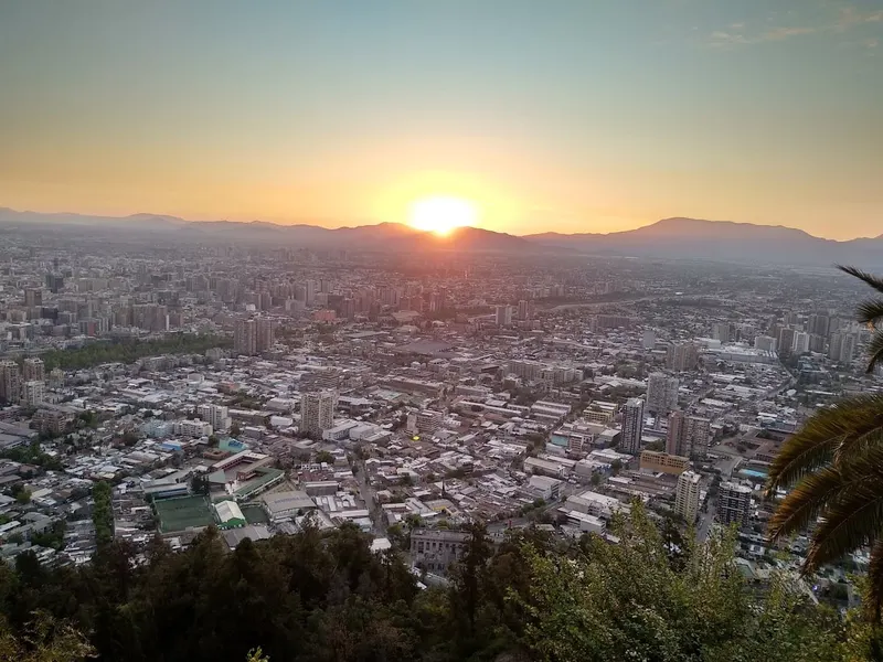
1Cerro San Cristobal
4.7★ · 4,283outdoorThe hill rises above Bellavista and Providencia with a funicular, cable car, sanctuary, pools, and the largest views across the basin. Smog and winter haze can limit the Andes panorama.
Wikipedia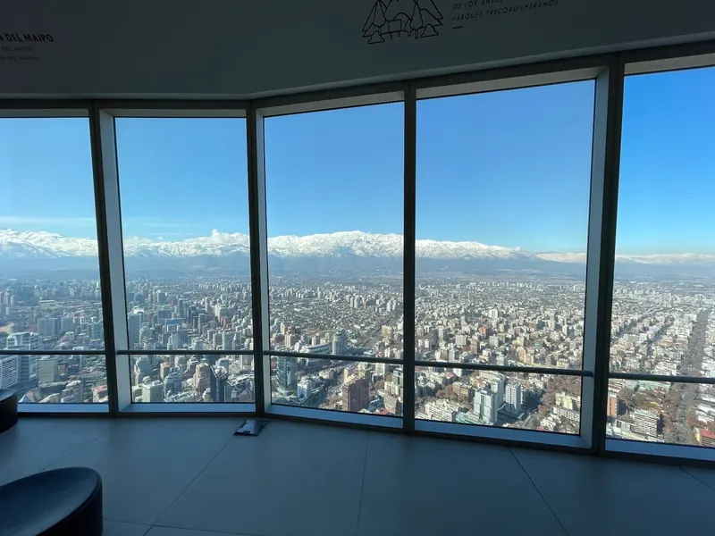 2
2Costanera Center and Sky Costanera
4.7★ · 25,558outdoorOpen dailyThe tower in Providencia is the tallest building in South America and has an observation deck above a large mall. It gives a practical weather check for Andes visibility.
 3
3Cerro Santa Lucia
4.6★ · 3,616outdoorThe small central hill was remade in the 19th century with terraces, fountains, stairs, and viewpoints. It is a short walk from Lastarria and the Universidad Catolica metro stop.
Wikipedia
Show 7 more sights
- 4La Moneda Palace
- 5Mercado Central and La Vega
- 6Plaza de Armas
- 7Metropolitan Cathedral of Santiago
- 8Museo Chileno de Arte Precolombino
- 9La Chascona
- 10Barrio Lastarria and GAM
Neighborhoods
 1
1Santiago Centro
The center is civic and busy, with Plaza de Armas, La Moneda, pedestrian streets, churches, museums, government offices, and strong weekday movement.
 2
2Lastarria and Bellas Artes
Lastarria feels compact and cultural, with cafes, bookstalls, GAM, Santa Lucia, cinemas, restaurants, and easy metro access.
 3
3Bellavista and Patronato
Bellavista is colorful and nightlife-focused below San Cristobal, while Patronato adds Korean, Middle Eastern, and bargain shopping streets nearby.
 4
4Providencia
Providencia is the practical middle city, with hotels, metro stations, Costanera Center, parks, restaurants, and good links east or west.
 5
5Las Condes and Vitacura
The eastern districts feel corporate and affluent, with offices, malls, hotels, parks, embassies, and clear Andes views from broad avenues.
 6
6Barrio Italia and Nunoa
These residential-cultural areas add design shops, cafes, theaters, bars, old houses, and a slower local pace south of Providencia.
Getting around
Metro de Santiago and RED buses use the Bip! card, with Line 1 tying Centro, Providencia, and Las Condes together. Air quality and long distances make metro-first planning smarter than relying on taxis across the whole basin.
Best time to do the Southern Cone trip
In May, the Southern Cone trip runs daytime highs from 19°C / 66°F to 20°C / 68°F, with nights down to about 5°C / 41°F at the coolest stop. Expect only a few wet days — up to 5 at the rainiest stop. Weighed across both stops, May is a good time to travel.
The most comfortable months across Buenos Aires & Santiago are November, April and September, based on average daytime temperatures and rainfall at every stop. May 2027 is a good time to go.
Check this route against your dates
Tripsapien starts with the sights on this page or places you paste, then checks hours, closures, booking pressure and neighborhoods for your exact May dates — across every city on the Southern Cone trip.
Plan this Southern Cone tripCommon questions about the Southern Cone trip
- When is the best time to do the Southern Cone trip?
- The most comfortable months across Buenos Aires, Santiago are November, April and September, based on average daytime temperatures and rainfall at each stop. May is a good time — see the per-stop weather below for the exact picture in May 2027.
- How many days do you need for the Southern Cone trip?
- A comfortable Southern Cone trip runs about 7–9 days, allowing roughly Buenos Aires 4, Santiago 3 nights plus travel between stops. Add a day if you want a slower pace or extra day trips.
- What's the route for the Southern Cone trip?
- The classic order is Buenos Aires & Santiago. Each city below has its own May weather, events and top-sights list.
- Will the sights be open during my May Southern Cone trip?
- Opening days and hours vary by weekday, season and public holiday, and they differ from city to city on a multi-stop trip. Paste your Southern Cone list into Tripsapien and it checks every place in Buenos Aires, Santiago against your exact dates, flagging closures and what needs booking ahead before you go.